


In the largest Google Earth update since 2017, users can now see the planet, including events in the Middle East and North Africa (MENA), in a whole new dimension.
Thanks to Timelapse in Google Earth, 24 million satellite photos have been combined into an interactive 4D experience over the past 37 years.
Over the past 15 years, millions of people have turned to Google Earth to explore the planet from infinite perspectives.
Users could reach the summit of Mount Everest or fly through their hometown. Since launching the program, Google has focused on creating a 3D copy of the world that depicts the planet in great detail, with features that entertain and enable everyone to create positive change.
Now everyone can watch time unfold and watch almost four decades of planetary change.
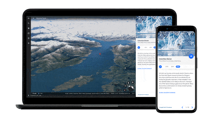
Over the last half century, the planet has undergone rapid changes in the environment more than any other moment in human history.
“Many users have undergone these changes in their own communities,” said Rebecca Moore, director of Google Earth, Earth Engine & Outreach. “I myself was among the thousands of Californians evacuated from their homes during state fires last year.”
For other people, the effects of climate change are felt as abstract and distant, like the melting of ice caps and the removal of glaciers. Thanks to Timelapse in Google Earth, users have a clearer idea of the changing planet, which shows not only the problems, but also ways to solve them, as well as the beautiful natural phenomena that unfold over decades.
To explore Timelapse in Google Earth, users simply need to go to g.co/Timelapse. There they can use the convenient search bar to select any place on the planet where they want to see time on the go.
Users can also open Google Earth and click on the ship’s wheel to find Timelapse on the Voyager storytelling platform to view interactive tours.
Google has also uploaded more than 800 Timelapse videos in both 2D and 3D for public use on g.co/TimelapseVideos. Users can choose any video they want as ready to use MP4 video, or relax and watch the video on YouTube.
From governments and researchers to publishers, educators and lawyers, Google says it’s excited to see people use Timelapse in Google Earth to shed light on the challenges facing the planet.
In the MENA region, users can find changes in: Algeria (Algeria); Bahrain (Manama); Egypt (Cairo, New Cairo, Dakhla Oasis and Sharm El Sheikh); Jordan (Dead Sea); Kuwait (Al-Hiran, Pearl City of Al-Hiran and Kuwait); Gabal El Uweinat (Libya, Sudan and Egypt); Qatar (Doha); Saudi Arabia (Al Jowf); and the UAE (Dubai).
Understand the causes of change on Earth
Google has worked with experts from Carnegie Mellon University’s CREATE lab in the United States to create the technology behind Timelapse.
Google Earth takes users on a tour of each topic to better understand them and their impact on Earth.
Placing time on Earth in the palm of your hand
It took a lot of what is called a “pixel crunch” in Earth Engine, Google’s cloud platform for geospatial analysis, to create the planet-sized video needed for the planet.
To add Timelapse animated images to Google Earth, the team collected more than 24 million satellite images from 1984 to 2020, representing quadrillion pixels.
It takes more than two million hours of processing on thousands of machines in Google Cloud to collect 20 petabytes of satellite images into a single 4.4-pixel video mosaic. This is equivalent to 530,000 videos in 4K resolution.
All of these calculations were performed at 100% carbon-neutral data centers, which are in line with the energy emissions that are part of the company’s commitment to building a carbon-free future.
As far as Google knows, Timelapse on Google Earth is the largest video on the planet. The creation of this video required a worldly collaboration.
The delay in Google Earth simply would not have been possible without NASA and the US Geological Survey’s Landsat program, the world’s first (and longest-running) civil Earth observation program. The programs of the European Union (EU) “Copernicus” and its satellites “Sentinel” were also involved.
What will you do with Timelapse?
Google invites anyone to take Timelapse into their own hands and share it with others, whether to marvel at the changing coast, monitor the growth of megacities, or track deforestation.
Time on Google Earth is a reduction in scale to assess the health and well-being of our only home, and it is a tool that can nurture and inspire action.
Visual evidence can cut out the substance of the discussion in such a way that words cannot convey complex problems to everyone. Take, for example, the award-winning documentary Nature Now, which uses satellite imagery to show the growing footprint of humanity on the planet.
The period of time for the next decade
In collaboration with its partners, Google will update Google Earth every year with new Timelapse images over the next decade. This is part of the tech giant’s hope that this prospect of the planet will spark discussions, encourage discovery, and change perspectives on some of our most pressing global issues.